The Fun Day and the Long Day

After a quick breakfast of oatmeal. We refilled our water. Instructed the boys in the proper way to break camp, and were off. Of course we were heading back to the car. What would a trip to Mammoth be without some cave tours. That is really why we only hiked a short bit on Sunday. We were trying to make it back to the visitors center by 10am, missed that, and the 4 hour tour. Oh well, the sun is out and it looks like we are going to have a beautiful, if not hot, spring day.
So we reorganize. Tours are selling out as we are planning (lesson: make reservations if there is something you really want to see.) We decide, after conspiring with a volunteer, to do the self guided historic entrance, and the 1pm new entrance tours. That way we see the widest variety of cave possible.


We take off for the historic entrance. The boys bouncing with excitement. Get the LNT and safety/medical condition speech, and descend into the cool air rising from the cave mouth. Down the steps into what feels like a ravine with a roof. After 100 feet or so you pass the gate the park uses to close the cave. Once past the gate the cave feels more like a tunnel. I follow the railing closely as we pass through dim pools of light, on the way out i notice that the same tunnel is much easier to navigate once my eyes have adjusted. The tunnel undulates between 12-15 ft wide and 6-10 foot tall. After a quarter of a mile opens into the largest underground space I've been in. 25 foot ceilings and roughly 100-150 foot in diameter, it is a roundish trianglish shape, with 3 main corridors. The cave is vast and dry, and bizarrely comfortable. After wandering as far as the park system lets you, and nosing around using our camera flash as a flashlight, who would have thought to bring one with us, we return to the surface and find a suitable place for lunch.


Our second tour is guided. Interestingly enough by the only ranger who is a native and descendant of the park property
Ranger Jerry Bransford. His tour is informative and interesting, and his personal knowledge and love of the area show through his drill sergeant demeanor and delivery. The new entrance is a strangely diverse tour. You enter through a 2 doored airlockish series of steps, and quickly descend through a twisting turning staircase that squeezes and seems to float out of the rock. Water is falling everywhere, sometimes on you, as you duck bounce and cajole yourself down the 280 foot vertical shaft. We stop for a presentation on cave development and a brief lights out in a room called Grand Central Station. We continue on the second section being a stable dry cave it is similar to the historic entrance. The third and final section of the cave is through the Onyx and Frozen Niagara rooms of which the major features are the stalactites and stalagmites deposits. Truly otherworldly, the boys, actually all of us, are excited to see the variety of different structures around every corner. A quick visit with some cave crickets on our way out, and we are back to the hiking at hand.


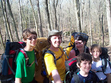
Back on the trail around 4:30 and we have 2-2.5 miles to hike to our campsite, or so we thought. Which brings me to another lesson. I was flying by the seat of my pants on the route organization of this whole trip, and had a number of options flying around in my mind and on my computer. I printed an old trail map, never got topo's and never, and here is the real lesson, checked with the rangers as to how current my map was, or trail conditions. Well. My map was wrong. So we hike, past our campsite from last night, everything's ok. To the junction of the Buffalo trail and the Good Spring Loop, everything's peachy. And we hike, along a flat and follow the contours of the hillside. And we hike.

All of us begin wondering where are turn off is. 2.5 miles, 3 miles, 3.5 miles, ummmm, still no turn off. The trail swings widely down into the hollow. and cuts arcing back up the other side.

Ian and I catch up with the rest of the group just over the ridge. The group moral has turned into frustration. I leave them to break, and scout ahead picking up my pace. In about a mile I reach the intersection with the collier ridge trail. Unsure how we missed the turn off I begin to scout the collier ridge campsite. It's between 7-7:30, and I'm thinking we could squat there, but I spot a small group heading up that trail. So I head back and meet the family coming at me a little more than a half mile from the intersection. The order to turn around is not met with happy faces.

We get back down to the stream bed, and I'm trying to decide if we venture off trail in the general direction of the campsite, or continue our hunt on trail. We decide to stick to the trail. Which is best as the little topo info on my map is horribly inaccurate. Lesson 3 get a map with good feature information. Angie's feet are hurting her and the boys are just generally exhausted so I once again bust out in front to see if I can make some heads or tails of where we went wrong. A short time, a mile and a half or so I have returned to the other trail intersection, completely dejected. We figure it out later that we should have made a left not a right, but we did what my map told us. It is getting real close to sunset, and my crew is miserable. I decide I'll hike back to them, we'll hike to the closest water, we've crossed 2-3 small streams. Then head down over the hill out of site of the trail and make camp. We find the flattest spot possible 150 feet or so off of the stream about two flats down from the trail.

We make camp quickly, and begin dinner all of us hanging out in one tent. The noodles with peanut sauce hit the spot for all but Ian, who has crashed in the corner of the tent. We are all short for the world, cleanup and quickly to bed. It has turned into a very long day!
Total expected miles: 3 plus cave miles 2
Total actual miles: 6 + 1.5 cave miles


 On the way down, when we passed through Louisville we noticed a sign that touted the "Whizzburger." So of course we had to try one. Angie hoped cheese whizz was involved, but there was none to be found. They were still good burgers, and thankfully for the other patrons it was a drive in. And on we drove. Great day, great vacation. I hope to someday see more of the great caves.


