of wine and walking

The travel blog of a hiking and backpacking wine lover.

Thursday, June 16, 2011

Great Smoky Mountains National Park 5


We begin to set up camp when the deluge hits rain pummels us hard. It hails again, and the boys tent quickly fills with water. We're cold, hungry, and tired as we re-arrange camp crawl into sleeping bags and sleep out the storm. Drenched, and downtrodden we awake to decide what to do. We were all looking forward to campsite 29 as it is supposed to be a wonderland of synchronous fireflies, a resident bear, hell benders in the creek and other wonders that we were excited to explore. What we got, a cold soaking and a flying squirrel chewing into one of our food bags.


I take a vote to see if everyone has the nerve to continue. We are scheduled for a 14 mile day, and I don't feel like pushing everyone farther than necessary because there is an easier 6 mile way to abort. The majority vote goes to continue so we trudge onward. Today is the day of the creek crossing. With many of them well into thigh region and the creeks roaring from the rain.


We pick our way carefully through the creeks, and quickly decent out of the mountains. Through Albright Grove a virgin stand of woods. Poplar trees dominate with 3-4 foot diameter trunks, and a couple dead stands with 6 foot trunks.


We lunch at a junction on an access road. A couple miles from a trail head. The closest to civilization we've been in a few days. A few families pass on day hikes taking a wide berth, we aren't sure weather we scare the little kids, the parents, or just smell that bad.

We start off on the Old Settlers Trail. Visit a 17th century graveyard. And pass by numerous stacked stone chimneys and chimney remains. When the park was formed this area was home to some 1000 people. Mostly farms, and much of it field and farmland. It's amazing how nature in some 80 years has reclaimed all of it in second growth forest. As we hike we often see, and for miles hike along stacked stone walls. Many of them 2-3 foot thick and sometimes 6-7 foot tall. The amount of work that had gone into building them is incredible. We often feel like a hobbit should appear as we round a bend.


Even though we are in the valley the trail winds up and down streams. We hike up old farm roads almost to the head water of the stream. Cross the ridge, and hike down the next stream returning to the valley. I've determined farmers only know how to build roads straight up hills.


We camp at an old homestead, only a chimney remains, that is reported to be haunted. We hear and see no evil, so that will have to remain a myth in our experience. Our hike out is much like the day before lot of little ups and downs, Chimneys, and stream crossings. With the addition of the heat and humidity of the lower elevations. The hike reminds me of southern Ohio and Pa. The little nagging resignation that we are almost done sets in. I always battle with the joy of completion, looking forward to a little civilization, and the remorse that the journey is almost over and wishes that it could maybe continue on for another day or two. We bath our feet in the waters of the Little Pigeon River upon the completion of our trip.

We set out for Gatlinburg to find a hotel, showers and food that hasn't been dehydrated. We walk down the main drag and Angie makes fun of my for my visible annoyance at all the people. A little culture shock has struck me with the massive crowds of the overtly tourist trap town. A couple quick pit stops at the visitors center and a drive to Clingmans Dome round out our trip before we head home.


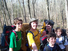
A beautiful week in the mountains with my favorite people in the world, who could ask for anything more.

Wednesday, June 15, 2011

Great Smoky Mountains National Park 4


After hanging out with 100 mile views at Charlies Bunion we decide to continue on. Another short 6 mile day awaits us.


We start our hike over what are known as the Sawtooths. The climbs are nowhere near as difficult as the previous 2 days and we wind our way up and down what seems like the spine of the Smokies. The ridge winds back and forth alternating views of North Carolina and Tennessee. The hills fall away on either side, and often both. There is a light wind, and the temperature maybe reaches the mid seventies. Unlike the low nineties when we pull into Cosby.


I'm really getting my trail legs now. We lunch trailside with humus pita and kalamata olives, with distant views of Fontana Lake. We make the Peck's Corner Shelter early. Isaac and Angie are beat. In conversation it feels like Nolan, Ian and I are all itching to do another 5 miles. We relax visit, nap and lounge the evening away. I pick the brain of Haiku a retired gentleman who earlier this year completed a 4 week 350+ mile section hike of the AT.


We break camp early as we have a longer day. Ten miles and the beginning of our decent out of the high peaks. The first half of the trail is similar to yesterday. I break out ahead, then eventually pick up my poles and slowly walk along having a spiritual little respite in the flat mountain top woods.


After summiting Mt. Guyot the forests begin to change again from the the wooded tops to open balds filled with mountain laurels and berry bushes. A storm front quickly rolls in late in the day, and we don our rain gear and begin our decent. The rain pours down hard and at times turns into hail the size of dimes. The rain begins to slack as we reach campsite 29. We've summited the last of our 10 peaks, and I'm a little saddened as I've felt in the rain we've hurried along, and I haven't paid as much attention to our surroundings as I'd have liked.

Tuesday, June 14, 2011

Great Smoky Mountains National Park 3


We sat in the shelter throughout the evening relaxing and eating dinner in the clouds and rain. Sharing our evening with a couple from Pittsburgh and their hiking partner. I took a short hike out to Cliff Tops, no views but a nice cloud walk. Mt. Le Conte is a massif with four peaks: High Top, Cliff Tops, Myrtle (or as the boys call it Mermaid) Point, and Balsam Point. We would summit 3 of those. A few games of 'Pass the Pigs' round out the night.


Before breakfast, Ian, Angie, Isaac and I would hike over High Top to Myrtle Point for a breathtaking above the clouds view just after sunrise. We take our time eating and packing up as we have a short 6 mile day to our next destination. The boys each place a rock on the growing 8 foot tall cairn on High Top. It is said that the hikers are trying to make Mt. Le Conte taller than Clingman's Dome (the Smokies highest point) one rock at a time. Our hike down the Boulevard trail is a long slow decent down a rocky ridgeline, ending in an extremely steep climb to the junction with the AT.


The boys take every opportunity though the week to turn over rocks to find salamanders. While examining one on the trail I spot, what from a distance looks like a rubber fishing worm in a tree behind Angie. It is a red-cheeked Jordan's Salamander. Our Shuttle said they are fairly rare, and only appear in the Smokies at elevation.


Just before the junction we divert to a scramble over the summit of Mt. Kepart to an area called the Jumpoff for lunch. The Jumpoff is a 3x12 foot overlook that has a view to die for. The sun is bright, the food good as we oogle the landscape and watch the people a couple miles across the valley play on Charlies Bunion (a destination on tomorrow's itinerary.)


My plans for yesterday's sunset on Cliff Top foiled by the rain. I seize the good weather and view we have and call Angie over to a small 2x2 foot precipice to ask for her hand. Sorry, no knee, there just wasn't room. After a short recovery she asks what I would do if she said no, push her? We hang out on the Jumpoff for another half hour before pushing to the Icewater Springs Shelter for the night.

Icewater Springs is packed. A couple Appalachian Trail thru-hikers, a couple AT section hikers, and a few other parties. We bask in the sun for a while recuperating. A deer wanders through the crowded shelter site uncaring about us humans. We decide to try to hike down to Sweat Heifer Falls for dinner. We turn back before the falls, hike back to the ridge and have dinner before nightfall. That is one steep trail.


Icewater is packed to the gills. The thru-hikers have moved on but there are still 16 in the shelter. The sunrise from our sleeping bags though is well worth the sardine conditions. After sunrise we quickly bail out of the shelter to make it to Charlies Bunion for breakfast.


Charlies Bunion is a rock outcropping offering views from Mt Guyot to the east and back to the Jumpoff and Mt. Kepart to the west. It is one of the 2 best dining rooms I've ever eaten at in my life.

Monday, June 13, 2011

Great Smoky Mountains National Park 2


The Alum Cave trail begins as a gradual ascent following the creek and winding through Arch Rock, an eroded hole through a small bluff that you hike through. The trail switches to following Styx Branch and begins putting on the elevation as we need to gain 2700 feet in the next four miles.


It is a very warm day as we reach Alum Cave for lunch. Alum Cave is a concave bluff just under half way to the top. Approximately 80 feet tall and 500 wide with a severely steep sandy floor. The break is well deserved and needed. We lunch at the cusp of the cave floor where some earlier hikers left a scattering of snacks that the none-too-shy red squirrels venture to gather.


Around the Gracie's Pulpit lookout we stop and watch a nesting pair of peregrine falcons chase off a third. The trail winds its way around a NW face and at times is only a foot or 2 wide with a cable handrail on the inner side to give a small amount of security. "Ok Isaac, hold tight" is an often repeated phrase. And I believe it is somewhere in this calf burning steepness that Isaac and Angie dub themselves "Team Slow." This is also where I realize that a change to my flatlander hiking style is necessary. Powering through the climbs is only destroying my calves, and my stamina.


Just as everyone is getting to the end of our proverbial ropes the top comes into sight and we make that last pushes to get to the top. Our shuttle driver said the second to the last mile will make you question your sanity, and she was not lying. We top out directly into a cloud on a flat wide boulevard just as rain begins to fall. A quick jaunt past the Le Conte lodge (which looks to be an interesting trip unto itself, small cabins and catering) to the shelter and we all can finally relax for the evening. Five miles and a final elevation 6593 feet in about 4 hours of hiking time, nice job kids.


While one of the busiest trails, especially with the lodge crowd heading up and all the day-hikers. Alum Cave is a gorgeous first day in the park. We started this trip off with a bang.