The travel blog of a hiking and backpacking wine lover.

Saturday, August 21, 2010

Isle Royal National Park the final days


As we descend from Mt. Ojibway we evidently missed the trail we really wanted in the fog, and eventually end up back at Daisy Farm. Not a big loss as the forests we passed through were some of Angie's favorite of the trip. If we were still going to Lane Cove this would have put a real kink in my side, but since we decided to camp at three mile it only adds 2 miles to our day, bringing the final total to 14. At check-in and speaking to another ranger this is not an uncommon occurrence, they might have been trying to make me feel better.


The woods from Ojibway to Daisy are a mix of pine, loose open bushy area thin wood, swamp, and a few open rocky areas. Sign and animal trails are everywhere on our hike. Angie is convinced that while she hasn't seen a moose or wolf, they have definitely seen her.


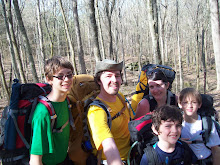
The trail especially between Daisy and 3 Mile is obstacle ridden without the rain, but with, it is down right treacherous. We all take a spill or two at some point, Isaac takes too many to count. But no real injuries. We wade through parts of the trail with water sometimes up to the mid point of my calf. It doesn't matter our feet can not get any wetter.

We pass a father and children who have decided to try and make it to Daisy Farm, and he asks me how much farther. At least 2.5-3 miles I tell him, which brings grumbling from his troops. We try to reassure them, but we hear later that his daughter was balling by the time they reached Daisy Farm.


We grab the last campsite at 3 Mile, next door to our first campsite, and set up the tents. The rain finally subsides. While I'm rigging the two tents together with a porch made from my extra poncho a ranger stops in. She warns us that a lone wolf has been sighted at Daisy Farm for the last 2 nights, and that they are going to try to haze him and scare him off. We heard about this from a gentleman we passed early in the day. The lone wolf evidently peeked into the shelter at him for a while the night before. He said the wolf looked a little thin of hip. As much as I would love a wolf sighting I'm not sure about a desperate wolf sighting. The ranger warns us not to let the kids outside by themselves after dark, and to be loud and scare it off if we see it. Also that we might want to hang our food.

We change into dry clothes, eat our Thai Peanut noodles, and play 'who am i' until we drift off to sleep.


We wake to a partly cloudy morning that gives away to the sun. Seeing as we only have a little over 3 miles this morning we take our time breaking camp. We lay our things on the rock slab beach to dry, and generally just hang out. When packing I have Isaac stand guard over our food and trash bag. There is a squirrel who is bound and determined to get into it. He jumps up on the bag even while one of us is standing right next to it.

I decide that we will hike the Tobin Harbor trail back to Rock Harbor. It is a little longer but I've read is much easier on the ankles. The trail flanks Tobin harbor and is just as pretty as every other trail we've been on, and much less dangerous to our feet. While hiking I mistakenly ask a passing hiker what the time is. 11:00. We usually hike a slow 1.5 mph if you include our frequent stops. We have over 3 miles to go which doesn't give us much time. I push everyone pretty hard, afraid that we might miss our boat. Of course I push so hard that we make the almost 4 mile hike in an hour and a half. Sorry guys. Next time I'll bring a watch.

We spend our last moments on the island polishing off the last of our snack bag. We get Ice cream sandwiches from the camp store. And talk to other hikers we've become acquainted with on the trail.


The crossing back to Copper Harbor is little more than a common boat ride, if we had 2 foot waves I'd be surprised. Naps, and a few games of 'pass the pigs' pass the time.

We do a little shopping and I try to get gas. The needle was on E when we left for the island, and I didn't have extra cash with me. The gas station only takes cash. So we decided to get gas upon our return. Of course when I get there the station is closed. So be warned the Copper Harbor gas station only takes cash, and is only open until 7. We eat dinner at the Mariner North again, I've never had smoked trout pizza before, very yummy. I ask our server where the next closest gas station is, and he replies Phoenix, but she is probably closed by now. Phoenix is a 2 street town over 30 miles away. So we head back over to the campground, the motels are booked. We at least can take a shower even if we are yet to sleep in a bed. Angie and I joke that if we can't get out of town on Sunday we will hock the car and give up, forever to stay in Copper Harbor.


I'm exceedingly proud of my family for being able to persevere on a trip that had a number of thing go wrong. There were plenty of chances for any of them to give up, and obstacles that would make giving up easy. What I'm amazed by more is the sheer beauty that Isle Royale holds. It truly is a magical island, and each of us has already expressed our desire to someday return. There truly is a reason that even though it is one of the least visited National Parks, it has one of the highest per capita rate of return visits. If it weren't for all the other places I wish to backpack. But that is for another story.

Friday, August 20, 2010

Isle Royale National Park the adventure continues


Sunrise over Moskey is breathtaking, and I'm quickly back in my bag for a short nap before our short day. Because we are only hiking about 6 miles, we sleep in, take a long pancake breakfast and break camp late. The hike today is mostly up as we head inland, none of it very steep, but up none the less. We run into a guy whose path we cross with throughout the trip, boat fiasco and all, he gives us a run down of the trail ahead and campsite we plan on staying at. We return the favor.


Lake Ritchie is very pretty but has a slight funk from an algae bloom the rangers warned us about. We lunch at lake Le Sage. A bit further than Isaac would have liked. All are pleased when shortly after lunch we cross over the Greenstone ridge and make it to camp at Chickenbone lake.


I'm continually amazed at how the character of the woods change around us. It seems that every trail we are on has it's own personality, and dominate feature/look. Today is the day of green as we head from Ritchie to the Greenstone. As we rise and fall over ridges we cross through swamps on plank bridges, in most of these giant skunk cabbage leaves have been broken over by the trampling of moose, and the ground is potted from their steps.


We end up at camp 6 which is one of the few lake side sites at West Chickenbone. Watch an OCD Red Squirrel gather nuts. Up the tree, stash the nut, down to a specific branch, jump to a small pine, stop, yell at us, down the tree, repeat. We have a nice dinner of mac-n-cheese followed by a fruit mix with grahams. Our new freezer bag cooking method is working well. The only failure was an oatmeal that refused to rehydrate. The lack of dishes to clean is awesome. The only other downfall is that it can be trying to eat from a quart bag.


I bust off for a day hike toward McCargo Cove while the boys whittle mallow sticks. I make it a good mile and a half when I decide to turn back. Hiking in the dark through the swampy areas around the lake do not sound appealing. Next time I'll remember to take my headlamp.


We finish the evening with mallows and watching an otter play and loon fish from across the lake. At dusk the boys spot a Snowshoe Hare at camp. I write in my journal while it is so quiet I hear only the dull thump of true silence.


Friday I awake to another beautiful sunrise. We are all up early as today is our long day, 12 miles down the Greenstone ridge. As we pack up camp thunderstorms start quickly rolling in. We make it back up to the Greenstone when they let loose. It rains almost continually from then until we set up our tents that night.


The walk is suppose to be our day of views, but the weather has other ideas. Visibility is at a max a hundred yards or so, but most of the time within 20-50 feet. Our ridge walk through the clouds is hauntingly beautiful. Glimpses of surrounding lakes and far ridges encourage our walk. Other than Ian we are in good spirits. He is having trouble dealing with the continual pound of the rain, not physical, he's as dry as can be and warm, just a general funk that threatens the morale of us all.


We hike on, Angie and I joke about having Lake Superior sloshing around in our boots. I joke at every northern lookout, "Hey boys, look, there's Canada". I set up the extra poncho I brought as for a little shelter just off the trail and we lunch. Lunch is a quick affair (tuna and lemon cous cous) as the longer we sit the more chilled we become. We have warmer clothing, but we are keeping it dry for when we get into camp. As long as we are moving we are all staying warm but the stops chill us quickly.


Lunch boosts morale, Ian has come to grips with the perpetual rain. The firetower is just a faded silhouette as we approach the summit of Mt. Ojibway. I can tell Angie is apprehensive as we climb as far as we can up the steel grated stairs. The view from just under the platform (the platform itself is closed) is 40 foot at best, but the we find it intriguing anyhow. The tower is now used for climate and air pollution monitoring.


Our original plan was to hike down the Greenstone ridge to Mount Franklin, then north to Lane Cove for the night. That would leave us with a 7 mile hike to get done before 2pm to catch our boat. We decided because of the rain, and the rough day today to hike south from Mt. Franklin to 3 mile and give ourselves an easy final hike in case the rain continues.

Wednesday, August 18, 2010

Isle Royale National Park Finally on the island


After a quick disembark – the obligatory LNT talk and registration – we are on the trail by 6:45. It feels like a steeple chase leaving Rock Harbor, but I let myself get caught up in in just to be on the trail.


Rock Harbor is no misnomer. Ankle breaker is more appropriate. Beautiful is also. Lichen and moss bearded pines and aspen dominate. Ferns abound as well as our new favorite on trail snack the Thimbleberry. We've never heard of them before, they are like a small flat red raspberry with a tart strawberry-esque flavor.


The trail is covered with root and rock, at times the only place to step is to balance on top of them. I never quite figure out the best rhythm between looking where I'm walking and the scenery around me. The rocks are the trail in the picture above.


We easily make Three mile campsite with a short stop at Suzie's Cave. Suzie's Cave is named for a girl who used to play there long ago. It is also an arch that, though now a couple hundred feet from the coast, used to be partially submerged. We make camp at Three Mile campsite and eat our dinner sitting on a stone slab watching the sun set over Lake Superior. It is one of the best dinning rooms I've ever eaten at.


We had a thunderstorm during the night that caused me to get up and put on the rainflys. The campsites are close together, but situated in such a way that you have a bit of privacy. There wasn't much wildlife moving about other than the red squirrels who are psycho. Similar to the black squirrels in Kent, but a "little" less aggressive. One confronted me, looked directly at me and clicked madly claiming our tent site as his domain.


Wednesday began as another game of leapfrog, we hoped back and forth with a young couple on their first trip, a group of 20 somethings, and a large group of women whom we later learned take backpacking trips all over the country once a year. Although somewhat better the beginning of the trail is still and ankle breaker. Along Rock Harbor/Snug/Superior up until the Daisy Farm Campground. It then we climb up and hiked on, or just under the ridge-lines from Daisy until we descended to Moskey Basin Camp.


We covered the 4 miles to Daisy Farm by lunch but hike another 1/2 to 3/4 of a mile to a nice lookout to have it. Before lunch we spot a couple Mersengers sleeping on the rocky shore, a bald eagle and take a break at an old mine (the Siskwit Mine) that is mostly unexciting.


Our second 4 miles on the ridges are surrounded by aspen and birch stands. Large rock slabs covered in lichen, scrub and small juniper break these wood. We catch glimpses of Moskey Basin below us and a grassy swamp to our right.

Ian is forever the trooper. Isaac is finicky and a little more touch-n-go. He stops a lot which can be trying, perpetually adjusting a pack or shoes, but he always finishes.


We spot a cow and calf moose track on the trail just outside of camp and scout near dusk, but a sighting isn't in the cards. Our camp, shelter 8, is a nice spot as long as your upwind of the privy, which we were, mostly. It is at the end of the basin overlooking a grassy cove. We wade, catch snails, threatening to eat them. Watch a mother and 6 young Mersengers dive all night, and try to identify a heron-ish while sitting, and duck looking while flying mostly black bird (turns out it is a Cormorant.) An unidentified bird of prey passes overhead, and a sandpiper feeds at our feet. It is an evening of relaxing and playing after a long beautiful hike.


We take a short walk to the point looking back up the basin at dusk. I split off hoping for a moose but do spot 2 Snowshoe Hare. Loon awaken us through the night and we hear the distant howl of a wolf.

Tuesday, August 17, 2010

Isle Royale National Park almost

We made it to Copper Harbor around 6pm on Saturday, after a long, long drive. Actually it was interesting watching the forest change as we drove north. Copper Harbor is a quaint old town about 10 streets long and 3 wide. We check into the Bella Villa a nice 50's cabinish style motel. We wandered town, ate fresh, local fish at the Mariner North: Walleye, Whitefish and Trout. Drove up Brockway Mountain (we learned later it wasn't the top) to get cell service (there's none in town) and let everyone back home know that we made it. We made it an early evening in anticipation of the next segment of our adventure.


A little background. Isle Royale became a national park in the 1940's. It is approximately 5o miles long and 10 at its widest. Native Americans, French, and Americans have used Isle Royale for mining, logging, fishing, trapping and tourism. Currently only the park service and the remaining life-leases on a dwindling number of cabins remain. The only approximation of civilization are the visitors center in Windigo on the west end. Cabins, motel and visitors center in Rock Harbor on the east. The park headquarters on Mott Island, remains of the Edison Fishery, a few scattered lighthouses, two firetowers, and the campsites. It is located in Lake Superior some 59 miles north of the northern most point of the upper peninsula. Along with numerous species of bird, and small mammals (squirrel, fox, beaver, otter) there are only 2 large mammals, wolf and moose. This makes Isle Royale a key place to study the dynamics of predator and prey inter-relations. We were going to hike a few of its over 160+ miles of trail.


I was up every hour through the night excited to get to Isle Royale. I've dreaming of this trip since I read about the island in the late 1990s. We took breakfast at the Tamarack Inn, and headed over to the dock to begin our voyage. A gorgeous double rainbow greeted us. We were told that the Queen wouldn't get out on Monday due to forecasted gale warnings, and that today's ride would be a rough one. As soon as we were out of the harbor the trip started to get interesting. 6'-8' waves that quickly started to escalate to 9'-10'ers. The waves were tightly spaced and in the complete the wrong direction for our crossing. After a half an hour we are barely 7 miles off of the shore in mostly the wrong direction. A couple 12' waves list the boat over. With 50 miles to go our captain decided to head back to the dock. By the time we return almost everyone was queezy, dramamine or not, and many were ill. The rest of our day was filled with naps induced by our non-drowzy Dramamine and a hike in Estivant Pines.


Estivant Pines is a virgin white pine forest. 500 year old eastern white pine with 2.5-3 foot diameter trunks are the highlight of the hike. It was beautiful, thick set of wood. The boys insisted we head down an unmaintained (it was signed as such) section of trail that ended, or more exactly we decided to turn around at, a swamp. Besides the pine: aspen, eastern white cedar, maple, and birch dominate the forest. The boys insist on taking a picture of bear scat for Papa Rob. It is an awe inspiring set of wood.

Monday arrives with a bluster. The winds howl all night and I know we aren't making it to the island. I let everyone sleep in and head to the dock to check in. Bad news return at 2, and even then the winds are hitting 45-50 mph. Maybe Tuesday.


We make the best of the day. On another cell phone trip we actually summit Brockway mountain. 1330 feet above sea level, about 800 above Lake Superior. Beautiful view, and a slight peak at Isle Royal some fifty-nine miles away (no camera with us of course.) We again have breakfast at the Tamarack Inn, hike a couple rocky and very windy miles of the Superior coast. The winds are easily hitting 50 mph and it is difficult to stand at times. The coast is filled with interesting wave battered stones and makes for excellent agate hunting. The boys fill their time playing and looking at stones, and watching the waves. We have to keep reminding ourselves that this is a lake and not an ocean, the only real clue is the lack of a salt smell.


We also hike out hunters point, the creek at Maganese falls down to lake Fanny Hooe and up Pauls Plunge. Which, if Paul did plunge, while steep, would still be more of a tumble.

I had marinated trout grilled over wood at the Harbor Haus. Which like this trip is a strange dichotomy. Fine dining in a small town with a lederhosen style theme. Weird, but the food and service were good. From there we walked across town pitched our tents and roasted marshmallows for desert. The motels were filled with 2 days of delayed voyagers plus the normal vacationers. With fingers crossed and trees rustling above my head I hoped tomorrow meant island.


Tuesday wakes to more wind. It has blown steady since Sunday evening, and will continue for 70 hours straight. We check on the boat and are told to return at 1:00. Back to our campsite for a quick breakfast and a hike down the edge of lake Fannie Hooe. The boat will actually depart. Sunday people are guaranteed, and a lottery is conducted for the left over spaces. The man ahead of me at check-in cancels. Now don't get me wrong, we were finished and going to bail if the boat didn't leave on Tuesday. But cancel within a half an hour of departure after waiting 2 days? I don't think so. Upon boarding the wind and waves appear worse than Sunday, but we don't care we are desperate and down Dramamine. The trip is long, 3 hours, mostly 6-8 foot waves with a few 11's for good measure. No where near as bad as Sunday. The worst part of the trip is how stuffy the boat is.