 We made it to Copper Harbor around 6pm on Saturday, after a long, long drive. Actually it was interesting watching the forest change as we drove north. Copper Harbor is a quaint old town about 10 streets long and 3 wide. We check into the Bella Villa a nice 50's cabinish style motel. We wandered town, ate fresh, local fish at the Mariner North: Walleye, Whitefish and Trout. Drove up Brockway Mountain (we learned later it wasn't the top) to get cell service (there's none in town) and let everyone back home know that we made it. We made it an early evening in anticipation of the next segment of our adventure.
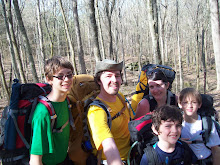
A little background. Isle Royale became a national park in the 1940's. It is approximately 5o miles long and 10 at its widest. Native Americans, French, and Americans have used Isle Royale for mining, logging, fishing, trapping and tourism. Currently only the park service and the remaining life-leases on a dwindling number of cabins remain. The only approximation of civilization are the visitors center in Windigo on the west end. Cabins, motel and visitors center in Rock Harbor on the east. The park headquarters on Mott Island, remains of the Edison Fishery, a few scattered lighthouses, two firetowers, and the campsites. It is located in Lake Superior some 59 miles north of the northern most point of the upper peninsula. Along with numerous species of bird, and small mammals (squirrel, fox, beaver, otter) there are only 2 large mammals, wolf and moose. This makes Isle Royale a key place to study the dynamics of predator and prey inter-relations. We were going to hike a few of its over 160+ miles of trail.

I was up every hour through the night excited to get to Isle Royale. I've dreaming of this trip since I read about the island in the late 1990s. We took breakfast at the Tamarack Inn, and headed over to the dock to begin our voyage. A gorgeous double rainbow greeted us. We were told that the Queen wouldn't get out on Monday due to forecasted gale warnings, and that today's ride would be a rough one. As soon as we were out of the harbor the trip started to get interesting. 6'-8' waves that quickly started to escalate to 9'-10'ers. The waves were tightly spaced and in the complete the wrong direction for our crossing. After a half an hour we are barely 7 miles off of the shore in mostly the wrong direction. A couple 12' waves list the boat over. With 50 miles to go our captain decided to head back to the dock. By the time we return almost everyone was queezy, dramamine or not, and many were ill. The rest of our day was filled with naps induced by our non-drowzy Dramamine and a hike in Estivant Pines.


Estivant Pines is a virgin white pine forest. 500 year old eastern white pine with 2.5-3 foot diameter trunks are the highlight of the hike. It was beautiful, thick set of wood. The boys insisted we head down an unmaintained (it was signed as such) section of trail that ended, or more exactly we decided to turn around at, a swamp. Besides the pine: aspen, eastern white cedar, maple, and birch dominate the forest. The boys insist on taking a picture of bear scat for Papa Rob. It is an awe inspiring set of wood.
Monday arrives with a bluster. The winds howl all night and I know we aren't making it to the island. I let everyone sleep in and head to the dock to check in. Bad news return at 2, and even then the winds are hitting 45-50 mph. Maybe Tuesday.


We make the best of the day. On another cell phone trip we actually summit Brockway mountain. 1330 feet above sea level, about 800 above Lake Superior. Beautiful view, and a slight peak at Isle Royal some fifty-nine miles away (no camera with us of course.) We again have breakfast at the Tamarack Inn, hike a couple rocky and very windy miles of the Superior coast. The winds are easily hitting 50 mph and it is difficult to stand at times. The coast is filled with interesting wave battered stones and makes for excellent agate hunting. The boys fill their time playing and looking at stones, and watching the waves. We have to keep reminding ourselves that this is a lake and not an ocean, the only real clue is the lack of a salt smell.

We also hike out hunters point, the creek at Maganese falls down to lake Fanny Hooe and up Pauls Plunge. Which, if Paul did plunge, while steep, would still be more of a tumble.
I had marinated trout grilled over wood at the Harbor Haus. Which like this trip is a strange dichotomy. Fine dining in a small town with a lederhosen style theme. Weird, but the food and service were good. From there we walked across town pitched our tents and roasted marshmallows for desert. The motels were filled with 2 days of delayed voyagers plus the normal vacationers. With fingers crossed and trees rustling above my head I hoped tomorrow meant island.

Tuesday wakes to more wind. It has blown steady since Sunday evening, and will continue for 70 hours straight. We check on the boat and are told to return at 1:00. Back to our campsite for a quick breakfast and a hike down the edge of lake Fannie Hooe. The boat will actually depart. Sunday people are guaranteed, and a lottery is conducted for the left over spaces. The man ahead of me at check-in cancels. Now don't get me wrong, we were finished and going to bail if the boat didn't leave on Tuesday. But cancel within a half an hour of departure after waiting 2 days? I don't think so. Upon boarding the wind and waves appear worse than Sunday, but we don't care we are desperate and down Dramamine. The trip is long, 3 hours, mostly 6-8 foot waves with a few 11's for good measure. No where near as bad as Sunday. The worst part of the trip is how stuffy the boat is.
No comments:
Post a Comment